Why Barad-dûr is probably bigger than you think.
​ Long post, so please bear with me.
I have recently been rereading the Lord of The Rings and the Plateau of Gorgoroth has been an obsession of mine as I reconstruct every nook and cranny of Frodo and Sam's Journey, this made me realize something that baffled me which you can kind of guess by the title.
1. Distances and Visibility
First, I would like to discuss the distances between the landmarks of the Plateau of Gorgoroth and how far they really are from each other, as the narrative tends to compress Frodo and Sam' journey toward Mount Doom.
As you may or may not know, Christopher Tolkien's map included in the Return of the King has a scale bar.
Using this scale, the distance between the Morgai and Mount Doom comes to roughly 40-43 miles, consistent with the narrator's statement that it lay 'forty miles at least. Likewise, measuring from the same point to the centre of the Barad-dûr symbol gives a distance of roughly 75–76 miles, making the following passage even more astonishing.
(RoTK, Book VI, Chapter I, The Stair of Cirith Ungol) :
"[...]and passing through found themselves on the very edge of the last fence of Mordor. Below them, at the bottom of a fall of some fifteen hundred feet, lay the inner plain stretching away into a formless gloom beyond their sight.
***"[...]Still far away, forty miles at least, they saw Mount Doom**, its feet founded in ashen ruin, its huge cone rising to a great height, where its reeking head was swathed in cloud. [...]Behind it there hung a vast shadow, ominous as a thunder-cloud, the veils of Barad-dûr that was reared far away upon a long spur of the Ashen Mountains thrust down from the North. "
Thus, from an elevation of roughly 1,500 feet on the Morgai, Frodo and Sam could distinguish Barad-dûr and its looming shadow even though it lay some forty miles farther away than Mount Doom.
From this first description, Barad-dûr appears less like an isolated tower and more like a vast fortress, its veils or possibly walls being compared to an ominous Thunder-cloud—a massive, looming presence dominating the horizon.
2. Tolkien's Approved Illustrations
Next is the (NoME) Nature of Middle Earth chapter that comments on the Pauline Baynes illustrations which Tolkien himself chose to depict Middle Earth:
(NoME, Part II chapter VI: Description of Characters):
"In 1970 Allen & Unwin published a poster-sized Map of Middle-earth, executed by the artist Pauline Baynes, and based upon that included in The Lord of the Rings. On the map itself are a series of vignettes portraying various locations significant to the story, such as the Barrow-Downs and Minas Tirith[...]
On seeing the finished art, Tolkien wrote a set of comments on these depictions of places and characters. Some of these comments are appreciative: e.g. Tolkien found four of the vignettes, sc. those depicting the Teeth of Mordor, the Argonath, Barad-dûr, and Minas Morgul, particularly well-executed, and described them as agreeing “remarkably with my own vision … Minas Morgul is almost exact”
I recommend looking at the map itself, both because it is beautiful and because Tolkien praised several of its depictions as agreeing "remarkably with my own vision."
3. Architectural Language and Prose
What concerns us here, however, is the illustration made by Pauline Baynes of Barad-dûr; the depiction makes the tower seem not only impossibly tall but also broad.
It resembles a massive complex of stone rather than the slender tower most artists depict, an impression reinforced by the following passage from The Breaking of the Fellowship:
"[...]and the haunted Mountains, and it looked upon Gorgoroth, the valley of terror in the Land of Mordor. Darkness lay there under the Sun. Fire glowed amid the smoke. Mount Doom was burning, and a great reek rising. Then at last his gaze was held: wall upon wall, battlement upon battlement, black, immeasurably strong,* mountain of iron,*gate of steel, tower of adamant, he saw it: Barad-dûr, Fortress of Sauron. All hope left him.
Particularly striking is the description "mountain of iron," which, admittedly, could be figurative. However, the comments in NoME and the earlier comparison to a thunder-cloud suggest otherwise.
To further support my argument, I will include additional evidence from the chapter "Mount Doom." This evidence may be the least reliable, since Tolkien usually describes the fortress in metaphorical rather than architectural terms until its fall. Nevertheless, I believe the following passages support my interpretation.
(RoTK, Book VI, Chapter 3, Mount Doom)
"[...]But as they went the most easterly of the roads followed them, until it ran off, hugging the skirts of the mountains, away into a wall of black shadow far ahead. Neither man nor orc now moved along its flat grey stretches.
"[...]*But far worse than all such perils was the ever-approaching threat that beat upon them as they went: the dreadful menace of the Power that waited, brooding in deep thought and sleepless malice behind the dark veil about its Throne. Nearer and nearer it drew, looming blacker, like the oncoming of a wall of night at the last end of the world." *
At this point Frodo and Sam are taking the road that goes northwest to the Isenmouthe from Barad-dûr and will soon move away from it across the land to reach Mount Doom.
The fortress has been described as a "mountain of iron," a "wall of night," a "tower of adamant," and a looming black shadow; of course, these descriptions could all be metaphorical, which leads to my next point.
4. The Height of Barad-dûr
The narrator also provides approximate heights for both the Morgai and Orodruin, allowing a rough comparison between them.
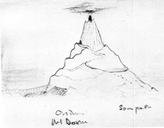
The Morgai rises roughly 1,500 feet above the plain, while Orodruin stands approximately 4,500 feet high (with Sammath Naur likely being around 4,300 feet, judging from Tolkien's drawing), as we read:
(RoTk, The Stair of Cirith Ungol, Book VI, chapter 1) "[...]The Mountain standing ominous and alone had looked taller than it was. Sam saw now that it was less lofty than the high passes of the Ephel Dúath which he and Frodo had scaled. The confused and tumbled shoulders of its great base rose for maybe three thousand feet above the plain, and above them was reared half as high again its tall central cone, like a vast oast or chimney capped with a jagged crater."
Further evidence appears when Sam and Frodo are climbing towards the Sammath Naur in the sloping mountain:
(RoTK, Book VI, Chapter 3, Mount Doom)
"Far off the shadows of Sauron hung; but torn by some gust of wind out of the world, or else moved by some great disquiet within, the mantling clouds swirled, and for a moment drew aside; and then he saw, rising black, blacker and darker than the vast shades amid which it stood, the cruel pinnacles and iron crown of the topmost tower of Barad-dûr."***
So it is strongly implied that Barad-dûr itself lay beneath a mantle of shadow, and that when the veils briefly parted Frodo caught sight of the cruel pinnacles and iron crown of its highest tower.
The use of the word "topmost" also suggests that Barad-dûr possessed multiple towers, with the one seen by Frodo being the highest.
Pauline Baynes' illustration of Barad-dûr—praised by Tolkien as closely matching his own vision—depicts these towers as relatively comparable in height, lending some support to that interpretation.
Further evidence comes when the veils of the topmost tower are removed and Frodo gazes at it:
"One moment only it stared out, but as from some great window immeasurably high there stabbed northward a flame of red, the flicker of a piercing Eye; and then the shadows were furled again and the terrible vision was removed. the Eye was not turned to them: it was gazing north to where the Captains of the West stood at bay[...]"
"[...]but still far from the reeking summit, to a dark entrance that gazed back east straight to the Window of the Eye in Sauron’s shadow-mantled fortress."
The mantle of shadow appears to have enveloped Barad-dûr itself. Nevertheless, when that mantle briefly parted Frodo saw the cruel pinnacles and iron crown of its highest tower.
Taken together, this evidence suggests that Barad-dûr may have risen above Orodruin, or at the very least the veil of shadow surrounding the fortress did.
I am inclined toward the first, as Pauline Baynes' illustration depicts Barad-dûr as not only extraordinarily tall but also remarkably broad.
5. The Meaning of Barad
The linguistic evidence also deserves consideration. I will now refer to Pelma Eldalamberon and the Sindarin root for Barad and Dûr to further my argument [From PE XVII,pg 37 and pg 85]
"S mor; morn· is a prefix = "black"; dur as Sindarin adj. = dark (with evil implications), as in Barad-dur. Cf. Minas Morgul (I 263 etc.) "Tower of Sorcery.""
"Barad-dur; barad 'a great towering building, (fort, city, castle) tower' ; dur 'dark"
"[See I 250 s.v. Elbereth, I 259 s.v. mar. Cf. EQS barad 'tower', dur 'dark' ; Etym. BARAT-, N barad 'tower, fortress', 003, D6-, EN dur 'dark, sombre' ; Barad-dur 'the Dark Tower', TI 178.]"
The Sindarin adjective dûr simply establishes the meaning 'dark', while the entry for barad is very revealing, since Tolkien glosses it as 'a great towering building (fort, city, castle), tower.
Thus, the noun barad encompasses "tower," "fortress," and even "city." While this does not by itself prove that Barad-dûr was a fortress-city, it does suggest Tolkien did not necessarily intend the name to denote a single isolated tower.
6. Sam's Vision and the destruction of the One Ring
Finally when the ring is cast into the cracks of Doom:
(RoTK, Book VI, Chapter 3, Mount Doom)
"And there upon the dark threshold of the Sammath Naur, high above the plains of Mordor, such wonder and terror came on him that he stood still forgetting all else, and gazed as one turned to stone. A brief vision he had of swirling cloud, and in the midst of it towers and battlements, tall as hills, founded upon a mighty mountain-throne above immeasurable pits; great courts and dungeons, eyeless prisons sheer as cliffs, and gaping gates of steel and adamant: and then all passed. Towers fell and mountains slid; walls crumbled and melted, crashing down; vast spires of smoke and spouting steams went billowing up, up, until they toppled like an overwhelming wave, and its wild crest curled and came foaming down upon the land. And then at last over the miles between there came a rumble, rising to a deafening crash and roar; the earth shook, the plain heaved and cracked, and Orodruin reeled"
The last description mentions a mountain throne which I believe can be seen in the illustration of the fortress made by Tolkien himself; this being the foundations that couldn't be destroyed by The Last Alliance, this spur also raised the already tall fortress even further above everything else.
The narrative mentions great courts and dungeons, eyeless prisons sheer as cliffs, and, most remarkably, gaping gates of steel. Based on Christopher Tolkien's map, Sam was also standing over four thousand feet above the plain at the Sammath Naur, giving him a commanding view across Gorgoroth. Between the elevation of both landmarks and the unusual nature of the vision itself, I think it's entirely plausible that he genuinely witnessed Barad-dûr collapsing.. It is also possible that Tolkien heightened some of the detail for literary effect, but I don't think those possibilities necessarily exclude one another.
The precise nature of Sam's "brief vision" remains open to interpretation. It may represent heightened perception associated with the Ring, literary narration, or a combination of these possibilities, since Tolkien does not specify.
These passages point toward Barad-dûr being not merely a tower but a fortress-city.
7. The War of the Last Alliance and the siege of Barad-dûr
The next argument draws upon The Silmarillion and Appendix B of The Lord of the Rings.
(The Silmarillion,Of the Rings of Power and the Third Age)
"[...]Therefore they made that League which is called the Last Alliance, and they marched east into Middle-earth gathering a great host of Elves and Men; and they halted for a while at Imladris. It is said that the host that was there assembled was fairer and more splendid in arms than any that has since been seen in Middle-earth, and none greater has been mustered since the host of the Valar went against Thangorodrim."
Then: (Appendix B: The tale of Years, The Second age)
"S.A 3434: The host of the Alliance crosses the Misty Mountains. Battle of Dagorlad and defeat of Sauron. Siege of Barad-dûr begins
S.A3440 Anárion slain.
S.A 3441 Sauron overthrown by Elendil and Gil-galad, who perish. Isildur takes the One Ring. Sauron passes away and the Ringwraiths go into the shadows. The Second Age ends.*"
Seven long years they besieged Barad Dûr and the greatest army in the world at that time couldn't break through.
How could the Last Alliance fail to breach Barad-dûr for seven years? While several explanations are possible, I would argue that its immense size, the capacity to sustain a prolonged siege, and alternate routes out of the fortress formed part of the answer.
(RoTK, Book VI, Chapter 3, Mount Doom)
"[...]He did not know it, but he was looking at Sauron’s Road from Barad-dûr to the Sammath Naur, the Chambers of Fire. Out from the Dark Tower’s huge western gate it came over a deep abyss by a vast bridge of iron, and then passing into the plain it ran for a league between two smoking chasms, and so reached a long sloping causeway that led up on to the Mountain’s eastern side."
So it is safe to assume the Sauron road and the Isenmouthe road were the most used but not the only ones; as stated by the text and seen in the illustration by Tolkien having a road going east and Mount Doom being west of the fortress
[RoTK, Book VI, chapter 2 :The Land of Shadow ]
"Neither he nor Frodo knew anything of the great slave-worked fields away south in this wide realm, beyond the fumes of the Mountain by the dark sad waters of Lake Núrnen; nor of the great roads that ran away east and south to tributary lands, from which the soldiers of the Tower brought long waggon-trains of goods and booty and fresh slaves. Here in the northward regions were the mines and forges, and the musterings of long-planned war"
8. Foundations, Scale, and Topography
My final argument concerns the topography of Barad-dûr itself. Tolkien's own illustration of the fortress provides what is perhaps our clearest view of the "foundations" mentioned in The Council of Elrond: the vast stone platform upon which Barad-dûr stood:
[FoTR, Book II, Chapter II: The Council of Elrond]
"Fruitless did I call the victory of the Last Alliance? Not wholly so, yet it did not achieve its end. Sauron was diminished, but not destroyed. His Ring was lost but not unmade. The Dark Tower was broken, but its foundations were not removed; for they were made with the power of the Ring, and while it remains they will endure."
Another source Tolkien himself approved and we should consider is Pauline Baynes' own map. If we examine Mordor closely, Barad-dûr is depicted as taller than Orodruin and considerably broader than it is in most maps and artistic depictions. The illustration also appears to show a substantial base beneath the tower that may represent these foundations.
Another, more speculative, piece of evidence comes from Christopher Tolkien's map. Although the symbol for Barad-dûr is unlikely to represent a precise footprint, measuring it against the map's scale indicates dimensions considerably larger than one mile. Since such symbols are necessarily schematic, I instead adopt one square mile as a deliberately conservative estimate for the fortress's built area.
(C.J.R.T, Map of Rohan, Gondor and Mordor made for the RoTK,The Lord of the Rings Illustrated by the Author, William Morrow)
Even assuming a conservative area of only one square mile, the fortress would occupy roughly 2.59 million square metres.
For comparison, the Burj Khalifa—the tallest building in the world—occupies roughly 29,000 square meters.
Of course, this does not mean the entire area encompassing the fortress was covered with buildings. The fortress probably included open courts, roads, walls, workshops, barracks, and other structures. Even allowing for that, the available area remains enormous by the standards of both historical fortifications and modern buildings.
For further perspective, an area of one square mile is roughly three quarters the size of Central Park and approximately equal to London's Financial District.
9. Measuring the map
Since the apparent distance between Orodruin and Barad-dûr is not immediately obvious from the narrative, I also measured Christopher Tolkien's map using its printed scale. Scale:
6.5 mm = 10 miles
1 mm ≈ 1.54 miles
Measurements: Morgai shelf → Orodruin: 27 mm ≈ 41.5 miles (closely matching "forty miles at least")
Orodruin to Barad-dûr: 22 mm ≈ 34 miles
Morgai shelf to Barad-dûr: 49 mm ≈ 75–76 miles
These measurements should not be taken as exact. The map symbols are necessarily schematic, especially for a structure as unusual as Barad-dûr. They do, however, provide a reasonable approximation of the relative distances involved.
Conclusion
While none of these pieces of evidence is conclusive on its own, together they point toward a remarkably consistent picture. Barad-dûr emerges not as an isolated tower, but as an immense fortress-city rising from a mountain-like foundation, with multiple towers, vast courts, bridges, gates, and walls. Whether it ultimately exceeded Orodruin in height cannot be proved, but I believe the cumulative textual and artistic evidence makes this conclusion very likely.
Personally, I believe the cumulative evidence points to Barad-dûr itself surpassing Orodruin in height—or, at the very least, being of comparable height. The spur upon which it was built would have elevated the fortress still further above the plain. I also believe it spread across a remarkably broad complex of towers, walls, courts, and battlements.
These observations also help explain the scale of devastation across the Plateau of Gorgoroth following the Ring's destruction.
I also believe Sam's account reflects an actual vision of Barad-dûr's destruction, even if Tolkien heightened some of the details for literary effect.
If you've read this far, thank you for indulging my fascination with Gorgoroth. I'd be interested to hear whether you think the textual evidence supports this interpretation.
(If you find any grammar mistakes or formatting issues , I apologize as I am on mobile and English is not my first Language)
Edit:Added several sources that were missing, chiefly Pelma Eldalamberon, a close-up of Pauline Baynes' map, and links to the individual vignettes mentioned in NoME.