Image 1 — Rainfall Analysis Over India under Super El-Nino and IOD
Image 2 — Rainfall Analysis Over India under Super El-Nino and IOD
Image 3 — Rainfall Analysis Over India under Super El-Nino and IOD
Image 4 — Rainfall Analysis Over India under Super El-Nino and IOD

Rainfall Analysis Over India under Super El-Nino and IOD

Source:
https://charts.ecmwf.int/products/seasonal_system5_climagrams_monsoon?base_time=202608010000&index_type=All%20India%20Rainfall

https://charts.ecmwf.int/products/extended-anomaly-tp?base_time=202608090000&projection=opencharts_southern_asia&valid_time=202609210000

1st Slide: It shows Long range Ensemble forecast for All India Rainfall and it shows less rainfall in the last months of monsoon, while rain picking up later in November and December overlapping with NE Monsoon season for South India hence as of now entire India will see less rainfall while during NE Monsoon South India will see good rainfall and cyclones possibly.

2nd Slide: each photo shows precipitation anomaly for 1 week starting from 10 August to 14 Sept
to me it looks like NE India and Indo Gangetic plains will see good rain especially NE India while rest of India will see less rainfall.

Winter rains looks normal to good for Himalayan region in India till the end of this year, and good rainfall is forecasted for the Himalayan regions in the upcoming 2 weeks due to monsoon axis shifting towards foothills as there's no low pressure dragging it towards central India. El nino has always been shown to increase winter rains over north india particularly Himalayan region so following the trend Himalayan region might see good rainfall but that's a long stretch since there's still time for core winter months i.e. more than 5 months so take it with a pinch of salt but generally saying good rainfall in winter months and weak rainfall in monsoon except these 2 upcoming weeks.

remember this one fact if there's no system, then monsoon axis will give good rain in ganga plains and Himalayas generally, also Tamil Nadu and Andhra Pradesh will see good rain towards leeward side since monsoon flow weakens in absence of system that allows sea breeze interaction and slowing of westerlies allowing evening thunderstorms.

though some good spells are forecasted for western ghats and NW India in upcoming 1 week after that looks tough.

4th Slide: El Nino will peak around Oct-November and it will be the time to see if it can surpass the 2015 strongest el nino record

3rd Slide: IOD will cross +1.0C and will peak around Sep-October which are last months of monsoon, and IOD has been associted with creating northwards travelling BSISO/MISO waves that might give rainfall as it passes through the subcontinent giving good rain especially in western ghats though need to see if the wave train even forms or not in first place

Forecast is based on ECMWF model and views are personal follow IMD for detailed info

u/Any-Profession-5509 — 10 days ago

Fastest El-Nino Ever recorded and possibly the strongest

Source: https://climatereanalyzer.org/clim/sst_daily/?dm_id=nino3.4

Atp I'm damn sure this is going to be the strongest el Nino in recorded history mark my words, it has already crossed +2.68C and the highest ever recorded was 2015 +3.01C, i remember 2015 was a flood year for south India what do you think will the extreme el Nino feed the NE monsoon to its peak causing another flood year for South? or do you think it will be an exception....for now monsoon deficit + Strong NE monsoon looks very likely if this happens, we will loose from 2 sides.

Btw this means guaranteed drought for North India, acc to IMD definition though sporadic rainfall will happen everywhere across country but that itself cannot refill the deficit.

u/Any-Profession-5509 — 11 days ago
CSIR Net Earth Science Help !!

Hey i tried to find CSIR net earth science lectures, books and study material but everything is quite less and i don't really know if that sparse material is even legit way or not.

so please can u suggest some courses, good books, courses or Yt channels which can be helpful?
any tips if you've given the exam would be really helpful

reddit.com
u/Any-Profession-5509 — 11 days ago

Super El-Nino Confirmed and Positive IOD Confirmed

1st Slide: Super Enno Chart officially crosses + 2.0 C mark and we will see its effect into mid-august and September where monsoon will be hit really hard especially N, NW India, South India, Western Ghats while NE India will get good rains and Central India Might get below-normal rains, this will drive the Monsoon deficit even lower.

2nd Slide: IOD has officially become positive with +0.63 C this enhances the SWM season sadly no one can survive the wraith of El-nino suppression over Indian subcontinent so IOD cannot completely offset el Nino though it might help offset some of it, but long-term predictions still look bleak.

Tougher Times ahead!! those who were saying Indian Monsoon dominated El-nino well it never won

Source: https://www.bom.gov.au/climate/influences/graphs/index.rnino.shtml?index=iod&period=weekly

u/Any-Profession-5509 — 11 days ago

This is how powerful rain shaft looks like

This is an isolated thunderstorm and you can clearly see where it is dumping rain and where it's not. The boundary between cold and warm front are clearly visible

u/Any-Profession-5509 — 11 days ago

Monsoon Improving Over India

Current rainfall deficient stands at -16.1 percent I'm expecting it to go around -10% and then again, we might see break phase though it won't be as bad as the earlier ones, so till now good monsoon is what we see only coz we see it improving not that monsoon is actually going well

ask any questions about your area i will reply but slowlyy...

u/Any-Profession-5509 — 27 days ago
▲ 23 r/IndiaWeather+1 crossposts

Mawsynram passes 6000 mm rain mark this year till 23 July 2026

Tamini ghat in Maharashtra recorded 4519 mm
Bhira in Maharashtra recorded 5634 mm

while second spot is between RKM sohra and mawkyrwat and both of them are in Meghalaya.

Meghalaya ko koii rok skta hai kyaaa!!! BIG LEAGUES Confirmed

I added western ghats data coz no one can beat them in SWM season data suggests they received more rainfall than meghalaya in SWM season even more than Meghalaya i.e. rainy months only

anyways half way there since annual rainfall for mawsynram is around 12000mm so yeah let's see currenty hopes are feeble but we can't trust rain Physics models or even Ai models like none of them predicted gujrat deluge of 1000 mm, they literally recorded 3rd highest rainfall in a day ever recorded in the history of Indian metrological department i.e. 1064 mm at Umergam (Gujarat) on 23 july 2026 beating many meghalayan records though the crown is still with Cherrapunji which is also in Meghalaya with 1563 mm/day on 16 June 1995

u/Any-Profession-5509 — 27 days ago

Extreme Rains recorded in South Gujarat

Sources:
https://www.gujaratweather.com/?page_id=14577

https://www.gujaratweather.com/?page_id=14363

Valsad has recorded its heaviest spell ever while Kaprada has got 1128 mm in last 48 hours and Umbergaon got 1039 mm in last 48 hours. Truly Awe standing rains

All of this is happening due to monsoon trough passing through central India and associated low pressure area which has increased monsoon westerly flow of wind >40 knots these are bashing the western ghats and major convergence formed at central India near Gujarat explaining heavy Rajasthan and Gujrat rains.

North India near West Up and NCR area etc will see on and off sharp showers today already some developments have been seen, so CJP protest mostly won't be affected weather will be chill and cloudy and sometimes rainy.

u/Any-Profession-5509 — 28 days ago

Thunderstorm expected in North Tamil Nadu today

Sea breeze has moved in and already we can see lot of pop ups forming today and tmrw seems good for rain though need to see if tmrw turns out to be cloudy then land heating will be minimal thus inhibiting rains

Chennai and nearby areas can see good rains in fact interior areas are seeing popups blooming slowly it will cover other areas, for now sharp isolated showers are possible later in evening these storms might converge with Sea breeze that you can see in this radar pic (a string of blue line or snakelike figure) as it moves into the city

u/Any-Profession-5509 — 1 month ago

El-Nino Getting Stronger, No sign of Proper Monsoon revival

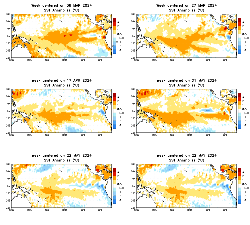
1st slide is SST animation of el nino from the date outlined (You can see a blob oh hot water travelling towards American continents i.e. from left to right)

2nd Slide El-Nino crossing +1.2 C already and now almost certain that it will become Super el nino around Nov 2026 with temps over +2.0 C

3rd Slide IOD bad news, earlier model was predicting strong IOD around sep with temp rising upto +1.2 C possibly, but chances are now bleaks recent models shows it to be borderline positive IOD till Sep.

4th Slide is real time SST dated 16 July 2026

fyi IOD is what enhances Indian Monsoon (including Pakistan, Bhutan, Nepal, Bangladesh and parts of Myanmar, Thailand etc), and El-Nino is what weakens it "generally".

Source:
https://www.bom.gov.au/climate/ocean/outlooks/?index=nino34#tabs=Graphs

https://www.bom.gov.au/climate/ocean/outlooks/?index=iod#tabs=Graphs

u/Any-Profession-5509 — 1 month ago

Super El-Nino Confirmed by NOV 2026

1st slide is SST anomaly over NINO 3.4 region

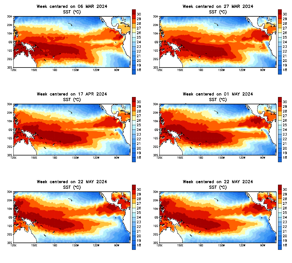
2nd Slide is Real SST value over NINO 3.4 region

3rd Slide is Realtime SST value dated for 16 July for the entire Globe

expect weak monsoon for Indian Subcontinent, NE India and South India (NE monsoon areas only) can have good rainfall rest of India GOOD LUCK

recently a low-pressure area has formed that will bring rainfall to many NW, NE, S and Central India, rain deficiency should be improved otherwise next monsoon break will be horrendous in next month August.

Source:
https://www.pmel.noaa.gov/elnino/realtime-data

https://cpc.ncep.noaa.gov/products/analysis_monitoring/enso_update/sstaanim.gif

https://cpc.ncep.noaa.gov/products/analysis_monitoring/enso_update/sstanim.gif

u/Any-Profession-5509 — 1 month ago

How can one travel to khaltse, leh alone?

Hello guys I'm going to khaltse, leh for some days due to some personal reasons.

I checked the flight, trains and buses. I found out that the nearest railway station is around 500km away and nearest airport is around 100km away, where the flight costs around 25k one way, i certainly don't have this much budget so I'm thinking of going via train.

I'm thinking of going to Srinagar via train and then taking the bus etc to travel to khaltse, but I have no idea if there are any buses or jeeps that go there.

So I want to know shall I even come to Srinagar in first place or some other city like maybe in Jammu, then from there how can i travel to khaltse, + I got to know it's a long journey so people take break between travelling by booking rooms, hence what can be the costs for room and where exactly i should be booking rooms?

reddit.com
u/Any-Profession-5509 — 1 month ago

Below Rain Forecasted Over Indian subcontinent for July, Aug, Sep and Oct

This long-term forecast is based on ECMWF model for July, Aug, Sep and Oct
this forecast is subject to change so prediction for more than a month in future isn't guaranteed but shows us possible scenarios developing, for now it looks like July will also go dry and deficient starting from 3rd week or bit early.

Entire India will face monsoon deficiency in July month, and that is almost certain, so all hopes are now on this dual low-pressure system before monsoon break phase starts again from mid-July

Source: https://charts.ecmwf.int/

u/Any-Profession-5509 — 2 months ago

Upcoming Low Pressure to bring relief in North and Central India

1st Image from ECMWF ensemble members predicting dual system, one weaker near Arabian sea most likely both will interact and become one near south UP, while second system already formed

2nd Image from AIFS model forecast for recent system

3rd image is the possible landfall area which is obviously near West Bengal

currently it doesn't seem cyclone will form at best depression which will bring heavy rains across north and central India

Source: https://charts.ecmwf.int/

u/Any-Profession-5509 — 2 months ago

Yes, these are clouds interacting with Islands

Source https://zoom.earth/maps/satellite/#view=27.8947,-116.6937,7z/date=2026-06-22,00:30,+5.5

Von Kármán vortex streets: a fascinating pattern in the atmosphere

These striking cloud formations appear when airflow passes around an isolated obstacle, such as an island or mountain peak, in a stable atmosphere with sufficiently strong, uniform winds.

Downstream of the obstacle, vortices are shed alternately, creating a regular chain of counter-rotating structures.

These vortices are then advected by the flow and gradually dissipate as they move into the wake.

A remarkable example of atmospheric dynamics visible from space.

Source: https://x.com/Windycom/status/2055200765363302590

u/Any-Profession-5509 — 2 months ago